Sanford Creek Canyon, Blind Spring Mtn, Lime Kiln Canyon Loop
Ride includes Lime Kiln Canyon, Hancock Peak, “Blind Spring Mtn Saddle Summit,” Adams Head Peak, Sanford Creek Canyon. This ride can be done in either direction, though we generally recommend ascending by Lime Kiln Canyon and descending through Sanford Creek Canyon in summer conditions.
4 Hours, 40 Miles
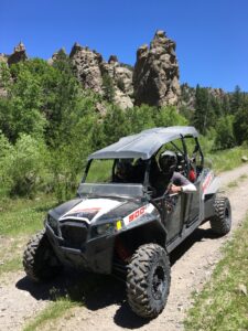
- The remote and spectacular Sanford Creek Canyon has year round water flow. This ride is open to larger 4 & 6 Seat UTV Side by Sides. As long as water levels are not too high and fast in the 12+ water crossing areas, this ride is safe, remote, rugged and spectacular!
- This one-of-a-kind canyon is noteworthy to geologists and back-country adventurers alike because it displays its highly unusual origins well.
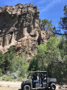
- Observe the ancient lithified (turned to stone) Volcanic mud flows (called Lahars) in Lower Sanford Creek Canyon that form it’s many shades of brown and grey walls about 1 mile east of the canyon mouth. These layers bare the colors of ash, sand & mud, and you can see many rocks and boulders haphazardly embedded in what is now the twisted stone layers of Lower Sanford Creek Canyon. The color, size, thickness and consistency of these rock-strewn sedimentary layers from these ancient volcanic lahars (flows) in this area is very unique.
- As you climb higher up Sanford Creek Canyon the pine trees will be joined by Aspen Groves that turn Golden in the fall. Aspen Trees bare the nickname of “Shakers” – in fall their Golden leaves make a musical “shaking” sound when the wind blows. As you reach the upper tree line- and above up to the 9200’ “saddle summit” -you’ll note thick layers of multi colored stone forming the huge mountains surrounding you. The enormous peak that towers over you to the East- even above tree-line is 10,426′ Adams Head Peak. The sedimentary layers of Adams Head are the result of gravity slides and lahars from the Marysvale Volcanic field to the North. These massive volcanic debris flows flowed into this area several different times between 19-28 million years ago when this was a lowland area. Over the next 20 million years these flows solidified into layers of rock through time and pressure. They also began the process of rising to their current heights- between 9000′-11000′ feet above sea level- through Tectonic Continental Uplift. At the same time the forces of water, weather and Erosion happened simultaneously, rendering the rugged and spectacular views we see today.
- Some of the Gravity slides that form this Southernmost end of the Sevier Plateau are the largest volcanic “lahars” geologists and have ever located or studied on our planet!
- These landslides or volcanic mudflows were the result of seismic and eruptive events associated with the tectonic uplift of the Marysvale Volcanic Field between 19 and 29 million years ago. The ancient center of the Marysvale field is located about 50 Miles North of Blind Spring Mountain- which is the 9536′ Pyramid shaped peak that you pass at the “Blind Spring Saddle Summit.”
- These massive flows moved from the volcanic high ground north of here. After coming to rest, uplift and erosion carved the spectacular views you see in all directions. From the Saddle Summit- in the distance to the West you see another Mountain Range – the Markagunt Plateau. The Markagunt Plateau was formed by the eroded, uplifted results of the Largest of all gravity slides previously mentioned. This Lahar/ Gravity Slide was thought to have been a 1200 square mile volcanic debris flow -moving North to South- All at once! The Markagunt Slide is thought to also be the last and the youngest of these titanic seismic events and is dated at about 19 million years ago.

As you look at these wildly shaped stratographic layers, note the extreme mixing of colors and materials- stones, sand, volcanic ash, mud, etc. Notice some gaping openings forming small and large caves. Some of these caves may have been air pockets- or the resting places of trees that have long since rotted away. Now visualize this huge flow of liquid concrete sliding down hill, following the lower contours of the ground. This giant mudslide is MILES across and hundreds of feet high. And it’s probably moving between 20 – 70 MPH! It picks up everything in its path and carries it. Trees, stones, giant ancient boulders, hills of volcanic ash and debris, all liquefied (a process called “Liquefaction”) and moving from high to low ground with “Gravity.”
- Here too you will see chunks of rhyolite and basalt lava’s, sometimes mixed with ancient sand, mud and ash, forming the layered mountains around you, along with layers of sandstone. Other times these rocks, plus quartz, agate are scattered about. Bright green and azure blue rocks are colored by the copper minerals malachite (green) and azurite (blue). The green tint can also be from iron deposited in an anoxic (underwater) environment. The red is more easily identified as containing oxidized iron. In Southern Utah and in numerous canyons in this area you’ll see green/red/white/purple sequences as well.
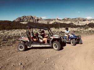
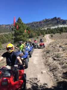
- The rugged “ride characteristics” of this Route means 3 of your 4 hours will be in the rugged Backcountry Canyons and High Altitude trails of the Sevier Plateau, aka the Dutton Mountain Range. Most of this is slow/ medium speed, with a few spots of rock crawling speed. The ENTIRE time you are in the Canyon Portions of this ride, (25 of the 40 miles), you’ll be in low range with all UTV’s and ATV’s if so equipped.
All ATV Rentals